
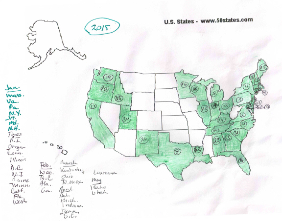
Idaho and Utah are new on the map this month, for a total to date of 34 — out of 51, because as a former D.C. resident I always include the Last Colony non-state in the tally.
The map seemed a tad colorless for the end of May, so I looked up May for the previous two years. I’d logged 36 by this time in 2013 and 2014, so 2015 isn’t far off the pace. Visually the big states across the nation’s midsection account for most of the difference. In 2013 and 2014 both Colorado and Kansas were colored in. In 2013 so were Nevada and Utah; in 2014 Nevada and Utah were still AWOL, but Missouri had shown up, as it never did in 2013.
On the plus side, Wisconsin is early this year. I’ve seen at least three different Wisconsins. A few days ago, while driving alongside Oak Bluffs harbor, I spied two interesting plates, so I pulled over, parked, and walked back to check them out. One was a South Carolina whose design I hadn’t seen before; the other was Alabama. I had both of them already. Worth the closer look, though.


What percentage of the states do you usually get by the end of the summer?
LikeLike
About 90% — there are usually 4–6 holdouts, one of which is always North Dakota. Montana has been scarce in recent years, and that stack from Oklahoma north to North Dakota are all pretty hard to get. Alaska and even Hawaii show up more often than one would expect.
LikeLike